Select Item below to DOWNLOAD - Once item is selected, right click and choose 'save as'
6982d664-ba31-4b2b-8ab5-2b1dc5a6b488
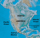
Shaded Relief Map of North America and Continental Shelf
Shaded Relief Map of North America and Continental Shelf
The thick continental crust of North America is surrounded by crust of the continental shelf (grey color) that thinned and submerged as the Atlantic Ocean and Gulf of Mexico opened.
Permission must be secured from the individual copyright owners to reproduce any copyrighted materials contained within this website. Digital assets without any copyright restrictions are public domain.
Modified from “Parks and Plates: The Geology of our National Parks, Monuments and Seashores,” by Robert J. Lillie, New York, W. W. Norton and Company, 298 pp., 2005, www.amazon.com/dp/0134905172.
Public domain:Full Granting Rights
Image
Geologic Resources Division, Code: GRD
12/04/2019
12/04/2019
Public Can View
Thursday, January 30, 2020 12:50:25 PM
Thursday, January 30, 2020 12:50:25 PM
map of north america showing continental shelf@10x.jpg
Wednesday, December 4, 2019 11:47:47 PM
jpg
794.4 kB
Scenic