Select Item below to DOWNLOAD - Once item is selected, right click and choose 'save as'
694f0677-ae88-4d4c-ad66-9aa84240af3f
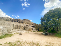
Campsite 44 fire ring, tent pad, and picnic table
Open sandy area with a large pine tree, fire ring, tent pad, and picnic table at the base of a granite formation.
hike-in 80 ft, rock, tent pad 9x9 ft, some shade
Permission must be secured from the individual copyright owners to reproduce any copyrighted materials contained within this website. Digital assets without any copyright restrictions are public domain.
Public domain:Full Granting Rights
Image
City of Rocks National Reserve, Code: CIRO
Latitude: 42.0745916666667, Longitude: -113.717819444444, Elevation: 1945.56416772554
City of Rocks National Reserve, Cassia County, Idaho
Latitude: 42.0699005126953, Longitude: -113.71199798584
City of Rocks National Reserve, Cassia County, Idaho
Latitude: 42.0699005126953, Longitude: -113.71199798584
05/29/2020
05/29/2020
Public Can View
Wednesday, May 12, 2021 2:29:30 PM
Monday, June 16, 2025 8:24:29 PM
36b.jpg
Apple Apple, iPhone 11 Pro 20, iPhone 11 Pro back triple camera 1.54mm f/2.4
1/400 sec at f / 2.4
1.54 mm
ISO 20
Friday, May 29, 2020 9:40:50 PM
jpg
2.5 MB
Scenic