Select Item below to DOWNLOAD - Once item is selected, right click and choose 'save as'
693727c7-20e2-42e9-b839-16d139e56b93
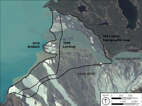
Ukak River Delta
Map showing the progradation (growth) of the Ukak River and Savonoski River delta from 1951 to 2010.
Map showing the progradation
(growth) of the Ukak River and Savonoski River delta
from 1951 to 2010. The abundant loose material
produced by the 1912 eruption has inundated the
rivers with sediment, which has been transported
downstream and is being deposited at the mouths
of the rivers.
Permission must be secured from the individual copyright owners to reproduce any copyrighted materials contained within this website. Digital assets without any copyright restrictions are public domain.
Satellite (IKONOS) imagery from 2010.
Public domain:Full Granting Rights
Image
Alagnak Wild River, Code: ALAG
Katmai National Park and Preserve, Code: KATM
Katmai National Park and Preserve, Code: KATM
Alagnak Wild River, Lake and Peninsula Borough, Alaska
Latitude: 59.003101348877, Longitude: -156.082000732422
Katmai National Park and Preserve, Alaska
Latitude: 58.5661087036133, Longitude: -154.889404296875
Latitude: 59.003101348877, Longitude: -156.082000732422
Katmai National Park and Preserve, Alaska
Latitude: 58.5661087036133, Longitude: -154.889404296875
01/01/0001
Public Can View
Thursday, September 2, 2021 12:43:35 PM
Thursday, September 2, 2021 2:55:48 PM
23_KATM_Fig_Ukak River Delta.jpg
Monday, January 1, 0001 12:00:00 AM
jpg
2.3 MB
Scenic