Select Item below to DOWNLOAD - Once item is selected, right click and choose 'save as'
6864c759beb24fab9d3dee86ed69c0ad
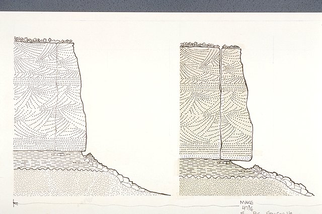
Illustration depicts the jointing and undercutting of the Fallen Rock formation.
Illustration depicts the jointing and undercutting of the Fallen Rock formation.
Illustrated together with IMS #05503.; Abbr=WE
U.S. National Park Service
Reflective Art
Government owns art and all reproduction rights.
Public domain
Geology, (HFC ArtTheme)
Image
Colorado National Monument, Code: COLM
Colorado National Monument, Mesa County, Colorado
Latitude: 39.0503997802734, Longitude: -108.692001342773
Latitude: 39.0503997802734, Longitude: -108.692001342773
Image Management System : IMS 05502
20190904
Exhibit 12/Graphic # 12-5
O 11
Public Can View
Organization: Harpers Ferry Center
Address: Harpers Ferry Center, 67 Mather Place, Harpers Ferry, WV, 25425, 304-535-5050
Address: Harpers Ferry Center, 67 Mather Place, Harpers Ferry, WV, 25425, 304-535-5050
Monday, October 7, 2019 2:48:34 PM
Monday, October 7, 2019 2:48:34 PM
05502.JPG
jpg
69.6 kB
Museum