Zion National Park, Utah
NPS Museum Accession Number : ZION-01134
Zion Legacy HPC Database Number : HPC-005259
Organization: Zion National Park
Position: Museum Curator
Address: Zion National Park, State Route 9, Springdale, UT 84767
Email: zion_museum@nps.gov
Detention dams, Potato Hollow, constructed 1950, have completely filled with sediment; water table raised, continued grazing hinders permanent establishment of grasses. ; ZION Museum and Archives Image ZION 9361 ; ZION 10153
Flooding of Pine Creek after very heavy showers as it flows below Bridge Mountain before joining the Virgin River. ; ZION Museum and Archives Image ZION 9202 ; ZION 15933
Virgin River in flood stage at the area of the 'Great Slide' below the Court of the Patriarchs. ; ZION Museum and Archives Image ZION 9012 ; ZION 7204
Virgin River on the rampage near the Zion Museum. ; ZION Museum and Archives Image ZION 9011 ; ZION 7623
Virgin River on the rampage in Zion Canyon. ; ZION Museum and Archives Image ZION 8626 ; ZION 15933
Flood damage - at outlet of sewage system from treatment plant near amphitheater of Watchman campground. ; ZION Museum and Archives Image ZION 8622 ; ZION 15933
Flood damage - Emerald Pools Trail near start of trail. ; ZION Museum and Archives Image ZION 8621 ; ZION 15933
Flood damage - footbridge at mouth of Birch Creek. ; ZION Museum and Archives Image ZION 8620 ; ZION 15933
Flood damage - West Rim Trail bridge near Grotto Campground. ; ZION Museum and Archives Image ZION 8617 ; ZION 15933
Flood damage - West Rim Trail bridge near Grotto Campground. ; ZION Museum and Archives Image ZION 8616 ; ZION 15933
Flood damage to Virgin River bank. ; ZION Museum and Archives Image ZION 8613 ; ZION 15933
B&W negative of flood damage to Virgin River bank. ; ZION Museum and Archives Image ZION 8611 ; ZION 15933
Flood damage to Virgin River bank. Image shows two men standing on riverbank in snow. ; ZION Museum and Archives Image ZION 8610 ; ZION 15933
Flood damage to rock wall on Virgin River, a quarter mile south of Court of Patriarchs. Record of damage or defective workmanship. ; ZION Museum and Archives Image ZION 8609 ; ZION 15933
Flood damage to rock wall on Virgin River, a quarter mile south of Court of Patriarchs. Record of damage or defective workmanship. ; ZION Museum and Archives Image ZION 8608 ; ZION 15933
Flood damage to rock wall on Virgin River, a quarter mile south of Court of Patriarchs. Record of damage or defective workmanship. ; ZION Museum and Archives Image ZION 8607 ; ZION 15933
The flooding and the partially collapsed bridge at Coal pits Wash on State Route 15 (now State Route 9). Damage caused by flood waters from the 'Great Flood of September' (September 17, 1961) which also claimed the lives of 5 people in the Narrows. [See ZI
The partial collapse of Coal pits Wash bridge on State Route 15 (now State Route 9) with several people standing on bridge. Note the debris and sandbar in foreground water still flows on both sides of sandbar. [See ZION 8601, 8599, and 8598 also.] ; ZION M
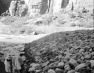
Flood damage - water removed several of the large boulders. ; ZION Museum and Archives Image ZION 8595 ; ZION 15933
Flood damage - water removed several of the large boulders used as revetments under new Oak Creek bridge. ; ZION Museum and Archives Image ZION 8594 ; ZION 15933
Flood damage - washed out terrace dam of irrigation system. ; ZION Museum and Archives Image ZION 8593 ; ZION 15933
Flood damage - 0.68-inch of rain in a few minutes. Debris covered road and bridge near Oak Creek residence area, looking downstream. ; ZION Museum and Archives Image ZION 8591 ; ZION 15933
Flood damage - 0.68-inch of rain in a few minutes. Looking up stream from bridge, debris above bridge near Oak Creek residence area. ; ZION Museum and Archives Image ZION 8590 ; ZION 15933
Flood damage - 0.68-inch of rain in a few minutes. Debris on top of bridge near Oak Creek residence area. ; ZION Museum and Archives Image ZION 8589 ; ZION 15933
Flood damage on park road near utility area; cloudburst at 6:30 p.m. leading to 1.08-inches of rain. [One of two images on single film strip for ZION 8584] ; ZION Museum and Archives Image ZION 8584 ; ZION 15933
Grader clearing debris from roadway after flood damage. ; ZION Museum and Archives Image ZION 8579 ; ZION 15933
Flood damage on park road near utility area; cloudburst at 6:30 p.m. leading to 1.08-inches of rain. [One of two images on film strip for ZION 8584] ; ZION Museum and Archives Image ZION 8584 N 2687 ; ZION 15933
Detention dams, Potato Hollow, constructed 1950, have completely filled with sediment; water table raised, continued grazing hinders permanent establishment of grasses. ; ZION Museum and Archives Image ZION 9361 ; ZION 10153
Flood damage repair - Zion Canyon, December 1966 flood. Between Birch Creek and Pine Creek on scenic drive. ; ZION Museum and Archives Image ZION 8561 ; ZION 15933
Flood damage repair - Zion Canyon, December 1966 flood. Grader fixing road between Birch Creek and Pine Creek on scenic drive. ; ZION Museum and Archives Image ZION 8559 ; ZION 15933
Flood damage repair - Zion Canyon, December 1966 flood. Grader fixing road between Birch Creek and Pine Creek on scenic drive. ; ZION Museum and Archives Image ZION 8558 ; ZION 15933
Flood damage repair - Zion Canyon, December 1966 flood. Between Birch Creek and Pine Creek on scenic drive. Damage repaired spring 1967. ; ZION Museum and Archives Image ZION 8557 ; ZION 15933
Flood damage repair - Zion Canyon, December 1966 flood between Birch Creek and Pine Creek on scenic drive. Repairs done spring 1967. ; ZION Museum and Archives Image ZION 8555 ; ZION 15933
Flood damage - down-cutting of Virgin River near revetment. ; ZION Museum and Archives Image ZION 8541 ; ZION 15933
Flood damage - just north of parking area for Court of the Patriarchs, threatening highway. ; ZION Museum and Archives Image ZION 8540 ; ZION 15933
River protection, Virgin River. ; ZION Museum and Archives Image ZION 8537 ; ZION 15933
Flood damage - section of valley road washed away in flood between Red Point and Temple of Sinawava. ; ZION Museum and Archives Image ZION 8526 ; ZION 15933
Flood damage - section of valley road washed away in flood between Red Point and Temple of Sinawava. ; ZION Museum and Archives Image ZION 8525 ; ZION 15933
Flood protection - wall and basket work. ; ZION Museum and Archives Image ZION 8392 ; ZION 15933
Flood protection - wall and basket work. ; ZION Museum and Archives Image ZION 8391 ; ZION 15933
Flood protection - wall and basket work. ; ZION Museum and Archives Image ZION 8390 ; ZION 15933
Flood protection - wall and basket work. ; ZION Museum and Archives Image ZION 8387 ; ZION 15933
Flood protection - wall and basket work. ; ZION Museum and Archives Image ZION 8386 ; ZION 10055
The river revetment repair; failure cracks appearing in repair work, about a half mile south of Court of the Patriarchs. ; ZION Museum and Archives Image ZION 8383 ; ZION 13319
River revetment repair. ; ZION Museum and Archives Image ZION 8382 ; ZION 7149
River revetment repair about a half mile south of the Court of the Patriarchs. Flood damage by use of piling and restoration of rock wall. ; ZION Museum and Archives Image ZION 8381 ; ZION 7149
River revetment repair failure, cracks appearing in repair work near Court of the Patriarchs. ; ZION Museum and Archives Image ZION 8379 ; ZION 13369
River revetment repair failure-cracks appearing in repair work near Court of the Patriarchs. ; ZION Museum and Archives Image ZION 8378 ; ZION 13349
Repair work to the revetment as a result of flood damage during construction of barrier piling. ; ZION Museum and Archives Image ZION 8373 ; ZION 7244
Repair of river revetment and flood damage during construction of barrier piling. ; ZION Museum and Archives Image ZION 8372 ; ZION 9846
Flood damage, East Rim road. ; ZION Museum and Archives Image ZION 7610 ; ZION 8927
Flood damage on East Rim road. ; ZION Museum and Archives Image ZION 7609 ; ZION 8930
Virgin River rampaging near the Temple of Sinawava. Control work necessary and carried out by dumping large boulders in the river. ; ZION Museum and Archives Image ZION 14931 ; ZION 15933
Flood damage at Temple of Sinawava parking area: controlled by revetment work. ; ZION Museum and Archives Image ZION 14891 ; ZION 15933
Unusually heavy flow in heaps canyon waterfall as a result of the Great Flood of September 17, 1961, in which five people lost their lives in the Narrows. ; ZION Museum and Archives Image ZION 14774 ; ZION 15933
Flood damage from down pour - 1.38-inches in one hour. High water in Oak Creek near bridge adjacent to Visitor Center employee's parking area. Nearly identical to: ZION 8523, negative number 3431b. ; ZION Museum and Archives Image ZION 14691 ; ZION 15933
The Virgin River near Temple of Sinawava at high flood stage. Control work necessary and carried out by dumping large boulders into the river (revetment work). Exhibit #5. ; ZION Museum and Archives Image ZION 13797 ; ZION 15933
Flood damage of debris washed on to park road. ; ZION Museum and Archives Image ZION 13711 ; ZION 15933
The May 14, 1941 landslide in Zion Canyon just below Birch Creek and Court of the Patriarchs. Landslide from the west bank of the Virgin River caused the stream to undercut the park road and remove a section of it. Note water flow behind the retaining wall