Select Item below to DOWNLOAD - Once item is selected, right click and choose 'save as'
5d96dddf-2583-45ec-9007-67beddb16cf6
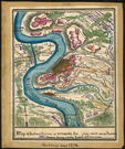
Map of Vicksburg during the Civil War
Map of Vicksburg that shows forts and troop arrangements.
Map of Vicksburg that shows forts and troop arrangements.
Library of Congress
Public domain
Image
Boston African American National Historic Site, Code: BOAF
Boston African American National Historic Site, Suffolk County, Massachusetts
Latitude: 42.3578987121582, Longitude: -71.0706024169922
Latitude: 42.3578987121582, Longitude: -71.0706024169922
01/01/1863
01/01/0001
Public Can View
Organization: Library of Congress
Friday, September 11, 2020 8:20:42 AM
Friday, September 11, 2020 8:20:42 AM
TS9-VicksburgMS.jpg
Monday, January 1, 0001 12:00:00 AM
jpg
77.3 kB
Historic
,
Map