Select Item below to DOWNLOAD - Once item is selected, right click and choose 'save as'
5b65d27c-7b00-4e5d-b140-2762a7214997
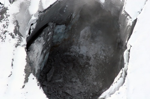
Fumarole Pit
Photograph of a non-venting fumarole pit in glacier ice on the summit of Fourpeaked Mountain.
Photograph of a non-venting fumarole pit
in glacier ice on the summit of Fourpeaked Mountain.
The diameter of this pit is about 50 m (160 ft), and the
floor is made of ash-covered blocks of ice.
Permission must be secured from the individual copyright owners to reproduce any copyrighted materials contained within this website. Digital assets without any copyright restrictions are public domain.
USGS-AVO
photograph by Kristi Wallace
Public domain:Full Granting Rights
Image
Alagnak Wild River, Code: ALAG
Katmai National Park and Preserve, Code: KATM
Katmai National Park and Preserve, Code: KATM
Alagnak Wild River, Lake and Peninsula Borough, Alaska
Latitude: 59.003101348877, Longitude: -156.082000732422
Katmai National Park and Preserve, Alaska
Latitude: 58.5661087036133, Longitude: -154.889404296875
Latitude: 59.003101348877, Longitude: -156.082000732422
Katmai National Park and Preserve, Alaska
Latitude: 58.5661087036133, Longitude: -154.889404296875
09/25/2006
09/25/2006
Public Can View
Friday, September 3, 2021 1:10:25 PM
Friday, September 3, 2021 2:15:32 PM
50_KATM_1160160940_44_8.JPG
Canon Canon, Canon EOS 20D
1/500 sec at f / 7.1
218 mm
ISO 200
Monday, September 25, 2006 5:02:39 PM
jpg
3.9 MB
Scenic