Select Item below to DOWNLOAD - Once item is selected, right click and choose 'save as'
599cb430-c4fb-4fa7-b843-b6ce0940a626
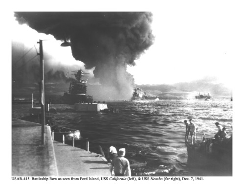
View of Attack from Ford Island USAR-415
Historic photo of attack on Pearl Harbor, looking out into harbor from land. Sailors aboard lifeboats in foreground and battleships engulfed in flames in background.
Battleship Row as seen from Ford Island. USS California (left) and USS Neosho (far right) engulfed in flames and smoke on December 7, 1941. Quay F2 with historic markings and paint scheme is clearly visible in foreground.
Permission must be secured from the individual copyright owners to reproduce any copyrighted materials contained within this website. Digital assets without any copyright restrictions are public domain.
NPS Photo/Pearl Harbor NM archives
Public domain:Full Granting Rights
Image
Pearl Harbor National Memorial, Code: PERL
Pearl Harbor National Memorial, Honolulu County, Hawaii
Latitude: 21.3675937652588, Longitude: -157.938568115234
Latitude: 21.3675937652588, Longitude: -157.938568115234
12/07/1941
03/10/2008
Public Can View
Friday, March 8, 2024 6:21:53 PM
Friday, March 8, 2024 6:44:41 PM
USAR415.jpg
Monday, March 10, 2008 11:12:38 AM
jpg
1.0 MB
Scenic