Select Item below to DOWNLOAD - Once item is selected, right click and choose 'save as'
594f5345524f434b2022020181129012
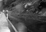
2018 El Portal Road debris flow | debris slide
Rocky debris on the road below Parkline Slab.
During a period of high intensity rainfall (0.6 cm/hour) there were several small debris slides and debris flows onto the El Portal Road within the area burned by the Ferguson Fire. Several small rocks fell onto the road at Parkline, and about 5 separate small debris flows came onto the road between Cookie Cliff and Arch Rock. These debris flows consisted of sand and silt.
UTM East: 257531; UTM North: 4173691; Elevation: 748
U.S. National Park Service
Copyright protection may exist: Contact Yosemite National Park for more copyright information.
CalTrans
Restrictions apply on use and/or reproduction:Copyright Unknown
Image
Yosemite National Park, Code: YOSE
Merced River Gorge
Latitude: 37.6783973273819, Longitude: -119.74945588
El Portal Road
Yosemite National Park, California
Latitude: 37.8399200439453, Longitude: -119.540397644043
Latitude: 37.6783973273819, Longitude: -119.74945588
El Portal Road
Yosemite National Park, California
Latitude: 37.8399200439453, Longitude: -119.540397644043
11/29/2018 | 20181130
11/29/2018
Public Can View
Organization: Yosemite NP
Position: Park Geologist
Address: El Portal, CA 95318
Email: greg_stock@nps.gov
Position: Park Geologist
Address: El Portal, CA 95318
Email: greg_stock@nps.gov
Wednesday, May 11, 2022 11:43:51 PM
Tuesday, August 9, 2022 5:48:38 PM
2018112901_2.JPG
jpg
1.3 MB
Events