Select Item below to DOWNLOAD - Once item is selected, right click and choose 'save as'
594f5345524f434b2022020160314012
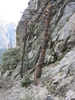
2016 El Capitan East Ledges rock fall
Impact marks on the trunk of a tree with a broken top.
A rock fall on the East Ledges descent route off of El Capitan resulted in substantial rock debris, damaged vegetation, and loose debris extending down the gully. Several small trees were destroyed and the larger trees stripped of branches.
UTM East: 268706; UTM North: 4179459; Elevation: 1785
U.S. National Park Service
Copyright protection may exist: Contact Yosemite National Park for more copyright information.
Unknown
Restrictions apply on use and/or reproduction:Copyright Unknown
image
Yosemite National Park, Code: YOSE
El Capitan
Latitude: 37.7332170743436, Longitude: -119.62469489
East Buttress
Yosemite National Park, California
Latitude: 37.8399200439453, Longitude: -119.540397644043
Latitude: 37.7332170743436, Longitude: -119.62469489
East Buttress
Yosemite National Park, California
Latitude: 37.8399200439453, Longitude: -119.540397644043
20160406
03/14/2016
Public Can View
Organization: Yosemite NP
Position: Park Geologist
Address: El Portal, CA 95318
Email: greg_stock@nps.gov
Position: Park Geologist
Address: El Portal, CA 95318
Email: greg_stock@nps.gov
Wednesday, May 11, 2022 11:49:38 PM
Thursday, July 28, 2022 8:51:28 PM
2016031401_2_unknown.jpg
jpg
289.9 kB
Events