Select Item below to DOWNLOAD - Once item is selected, right click and choose 'save as'
594f5345524f434b2022020140527021
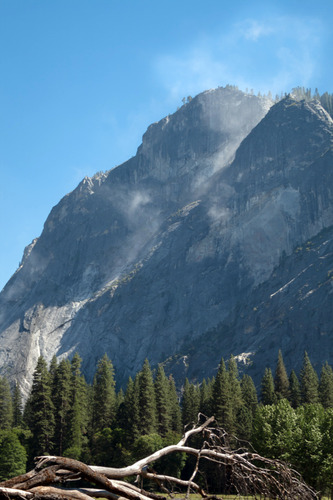
2014 Curry Village rock fall
A dust cloud dissipates as it rises up a steep rock cliff.
A rock fall from Glacier Point, directly behind (south of) Curry Village produced sharp cracking sounds. The source area was on the upper headwall of Glacier Point, from the east facing cliff below and west of the uppermost headwall.
UTM East: 272993; UTM North: 4179180; Elevation: 2058
U.S. National Park Service
Restrictions apply on use and/or reproduction (Copyrighted material): This Item is protected by copyright and/or related rights. Copyright: Keeler, Kirk
Kirk Keeler
Public domain:Restrictions may apply on use and/or reproduction
image
Yosemite National Park, Code: YOSE
Glacier Point
Latitude: 37.7317777928405, Longitude: -119.57600504
Curry Village
Yosemite National Park, California
Latitude: 37.8399200439453, Longitude: -119.540397644043
Latitude: 37.7317777928405, Longitude: -119.57600504
Curry Village
Yosemite National Park, California
Latitude: 37.8399200439453, Longitude: -119.540397644043
20140527
05/27/2014
Public Can View
Organization: Yosemite NP
Position: Park Geologist
Address: El Portal, CA 95318
Email: greg_stock@nps.gov
Position: Park Geologist
Address: El Portal, CA 95318
Email: greg_stock@nps.gov
Wednesday, May 11, 2022 11:52:58 PM
Thursday, July 28, 2022 8:37:39 PM
2014052702_1_Kirk_Keeler.jpg
jpg
1.1 MB
Events