Select Item below to DOWNLOAD - Once item is selected, right click and choose 'save as'
594f5345524f434b2022020080707012
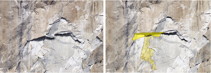
2008 El Capitan Southeast Face rock fall
Before and after photos of a rock fall source area, source area outlined in yellow polygon.
A rock fall from the southeast face of El Capitan, just east of the Footstool below the North America Wall. The failure occurred from the long, roughly horizontal roof extending over the scar.
UTM East: 268059; UTM North: 4179245; Elevation: 1489
U.S. National Park Service
To the best of our knowledge we believe this image to be copyright free and in the public domain. When using this asset for any purpose, including online, credit: 'Courtesy U.S. National Parks'
NPS Photographer
Public domain
image
Yosemite National Park, Code: YOSE
El Capitan
Latitude: 37.7311266066328, Longitude: -119.63196161
Southeast Face
Yosemite National Park, California
Latitude: 37.8399200439453, Longitude: -119.540397644043
Latitude: 37.7311266066328, Longitude: -119.63196161
Southeast Face
Yosemite National Park, California
Latitude: 37.8399200439453, Longitude: -119.540397644043
20080917
07/07/2008
Public Can View
Organization: Yosemite NP
Position: Park Geologist
Address: El Portal, CA 95318
Email: greg_stock@nps.gov
Position: Park Geologist
Address: El Portal, CA 95318
Email: greg_stock@nps.gov
Thursday, May 12, 2022 12:01:09 AM
Thursday, July 28, 2022 8:01:25 PM
2008070701_2_NPS.jpg
jpg
245.2 kB
Events