Select Item below to DOWNLOAD - Once item is selected, right click and choose 'save as'
594f5345524f434b2022020070115012
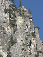
2007 Castle Cliffs rock fall
A close perspective of source area on cliff, circled in yellow.
A rock fall from the Castle Cliffs north of the National Park Service stables occurred causing numerous rock impacts sounded like thunder and lasted about 30 seconds. Inspection in the morning revealed a fresh boulder in the gully directly north of the stables leading up to Sunnyside Bench and two large boudlers resting approximately 100 m upslope of the Valley Loop Trail north of the National Park Service stables. One smaller flyrock boulder fell onto the Valley Loop Trail in the talus slope section north of the stables. Considerable vegetation on the talus slope was damaged, with several live oaks completely shattered and many others broken and scarred.
UTM East: 271949; UTM North: 4181919; Elevation: 1858.25
U.S. National Park Service
To the best of our knowledge we believe this image to be copyright free and in the public domain. When using this asset for any purpose, including online, credit: 'Courtesy U.S. National Parks'
NPS Photographer
Public domain
image
Yosemite National Park, Code: YOSE
Indian Canyon
Latitude: 37.7561805422659, Longitude: -119.58870035
Castle Cliffs
Yosemite National Park, California
Latitude: 37.8399200439453, Longitude: -119.540397644043
Latitude: 37.7561805422659, Longitude: -119.58870035
Castle Cliffs
Yosemite National Park, California
Latitude: 37.8399200439453, Longitude: -119.540397644043
20070115
01/15/2007
Public Can View
Organization: Yosemite NP
Position: Park Geologist
Address: El Portal, CA 95318
Email: greg_stock@nps.gov
Position: Park Geologist
Address: El Portal, CA 95318
Email: greg_stock@nps.gov
Thursday, May 12, 2022 12:02:26 AM
Thursday, July 28, 2022 7:55:22 PM
2007011501_2_NPS.jpg
jpg
1.5 MB
Events