Select Item below to DOWNLOAD - Once item is selected, right click and choose 'save as'
54dbd056-2db2-4b54-9def-7b167442e19c
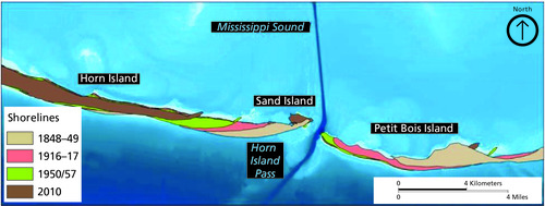
Map showing movement of western Petit Bois and eastern Horn Islands, 1848–2010.
. Map showing the shoreline movement of western Petit Bois and eastern Horn Islands, 1848-2010. The map shows the position of shoreline at 4 periods of time: 1848-49, 1916-17, 1950/1957, and 2010.
Map showing movement of western Petit Bois and eastern Horn Islands, 1848–2010.
Permission must be secured from the individual copyright owners to reproduce any copyrighted materials contained within this website. Digital assets without any copyright restrictions are public domain.
Figure modified from Byrnes et al. (2013, figure 7). Reprinted with permission from Mark Byrnes (Applied Coastal, Inc.).
Public domain:Full Granting Rights
Image
Gulf Islands National Seashore, Code: GUIS
Gulf Islands National Seashore
Latitude: 30.3730602264404, Longitude: -86.9099731445313
Latitude: 30.3730602264404, Longitude: -86.9099731445313
01/01/0001
Public Can View
Monday, June 14, 2021 1:55:50 PM
Monday, June 14, 2021 1:55:50 PM
Figure 17. GUIS_MigratingShorelines_0626-2018_tte-02.jpg
Monday, January 1, 0001 12:00:00 AM
jpg
1.7 MB
Scenic