Select Item below to DOWNLOAD - Once item is selected, right click and choose 'save as'
54446b8d-1a26-4e9c-a620-5d268589b504
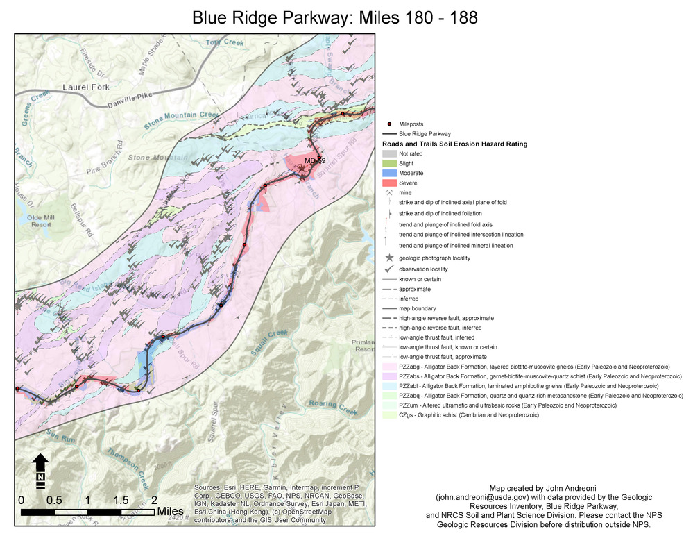
Example Map Displaying Data Sets Relevant for Slope Stability Information in Virginia.
Information featured includes mileposts, mines, strike and dip of inclined axial plane of fold and of inclined foliation, trend and plunge of included fold axis and of inclined intersection lineation, trend and plunge of include mineral lineation, geologic photograph locality, observation locality, geologic contacts, fault lines, and geologic map units PZZabg-Alligator Back Formation, layered biotite-muscovite gneiss (EarlyPaleozoic and Neoproterozoic), PZZabs-Alligator Back Formation, garnet-biotite-muscovite-quartz schist (EarlyPaleozoic and Neoproterozoic), PZZabl-Alligator Back Formation, laminated amphibolite gneiss (EarlyPaleozoic and Neoproterozoic), PZZabq-Alligator Back Formation, quartz and quartz-rich metasandstone (EarlyPaleozoic and Neoproterozoic), PZZum- altered ultramafic and ultrabasic rocks (Early Paleozoic and Neoproterozoic), and CZgs-Graphitic schist (Cambrian and Neoproterozoic). Roads and trails soil erosion hazard ratings range from not rated, slight, moderate, to severe.
There is no dedicated geohazards map for the parkway in Virginia. This map incorporates data from two sets applied to mileposts 180–188: (1) GRI GIS data set blrn_geology.mxd (source map: Carter et al. 2016) includes the BLRN geologic units and observation data, and (2) USDA Natural Resources Conservation Service soil erosion interpretation (available via Web Soil Survey; https://websoilsurvey.nrcs.usda.gov/app/HomePage.htm). Parkway boundary, roadway, and milepost data layer provided by parkway staff.
Permission must be secured from the individual copyright owners to reproduce any copyrighted materials contained within this website. Digital assets without any copyright restrictions are public domain.
Map by John Andreoni (Natural Resources Conservation Service, Soil and Plant Science Division).
Public domain:Full Granting Rights
Image
Blue Ridge Parkway, Code: BLRI
Blue Ridge Parkway
Latitude: 36.4365005493164, Longitude: -81.070556640625
Latitude: 36.4365005493164, Longitude: -81.070556640625
01/01/0001
Public Can View
Thursday, May 27, 2021 1:00:01 PM
Thursday, May 27, 2021 1:00:01 PM
17_BLRI_VA_soilandgeo.jpg
Monday, January 1, 0001 12:00:00 AM
jpg
1.5 MB
Scenic