Select Item below to DOWNLOAD - Once item is selected, right click and choose 'save as'
536c6d08035f42198762a44e2e88d97e
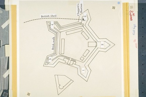
Small diagram of the star fort showing the location of the bastions and the trajectory of the shell that hit Fort McHenry's Bastion No. 3 (with type overlay).
Small diagram of the star fort showing the location of the bastions and the trajectory of the shell that hit Fort McHenry's Bastion No. 3 (with type overlay).
Diagram photographed with type overlay in place.; Abbr=WE
U.S. National Park Service
Reflective Art
Government owns art and all reproduction rights.
Public domain
Fortifications/Coastal Defenses, (HFC ArtTheme)
Image
Fort McHenry National Monument and Historic Shrine, Code: FOMC
Fort McHenry National Monument and Historic Shrine, Baltimore city, Maryland
Latitude: 39.2619018554688, Longitude: -76.5803985595703
Latitude: 39.2619018554688, Longitude: -76.5803985595703
Image Management System : IMS 04697
20190904
01/01/1982 - 12/30/1982
Exhibit 16/Graphic # 16-7
I 6
Public Can View
Organization: Harpers Ferry Center
Address: Harpers Ferry Center, 67 Mather Place, Harpers Ferry, WV, 25425, 304-535-5050
Address: Harpers Ferry Center, 67 Mather Place, Harpers Ferry, WV, 25425, 304-535-5050
Monday, October 7, 2019 2:55:57 PM
Monday, October 7, 2019 2:55:57 PM
04697.JPG
jpg
46.9 kB
Museum