Select Item below to DOWNLOAD - Once item is selected, right click and choose 'save as'
51208152df004236821e0d533380645b
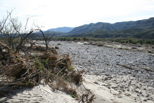
Boquillas Bar 14. River Mile 788.4. December 2008.
Photo of the Rio Grande
Rio Grande vegetation monitoring, "Boquillas Bar 14" photopoint at river mile 788.4, December 2008.
U.S. National Park Service
Bar 14 is a highly irregular separation and flow expansion deposit. It is thick with vegetation. The upper end is 6.5 to 8 feet above the WE. The lower portion of the bar is protected by a natural levee and low spots behind the levee are 9.5 feet above the water. The photo point is on the Texas side on top of a gravel outcrop.
Permission must be secured from the individual copyright owners to reproduce any copyrighted materials contained within this website. Digital assets without any copyright restrictions are public domain.
NPS Photo
Public domain:This photo was taken by staff at Big Bend National Park and is part of the public domain.
Image
Big Bend National Park, Code: BIBE
Rio Grande Wild and Scenic River, Code: RIGR
Rio Grande Wild and Scenic River, Code: RIGR
Latitude: 3249178.0436, Longitude: 706215.7056
Big Bend National Park, Brewster County, Texas
Latitude: 29.3278388977051, Longitude: -103.205894470215
Rio Grande Wild and Scenic River, Texas
Big Bend National Park, Brewster County, Texas
Latitude: 29.3278388977051, Longitude: -103.205894470215
Rio Grande Wild and Scenic River, Texas
12/2008
12/01/2008 - 12/30/2008
Public Can View
Person: Resource Management
Organization: US National Park Service
Address: Big Bend National Park, P.O. Box 129, TX 79834-0129
Organization: US National Park Service
Address: Big Bend National Park, P.O. Box 129, TX 79834-0129
Saturday, May 2, 2020 10:02:48 AM
Saturday, May 2, 2020 10:02:48 AM
BIBE_RioGrande_RioGrandeVegMonitoring_788.4BoquillasBar14L_20081213_9.JPG
jpg
5.3 MB
Monitoring