Select Item below to DOWNLOAD - Once item is selected, right click and choose 'save as'
50f027f050de4decbe6e07d9eb711fc6
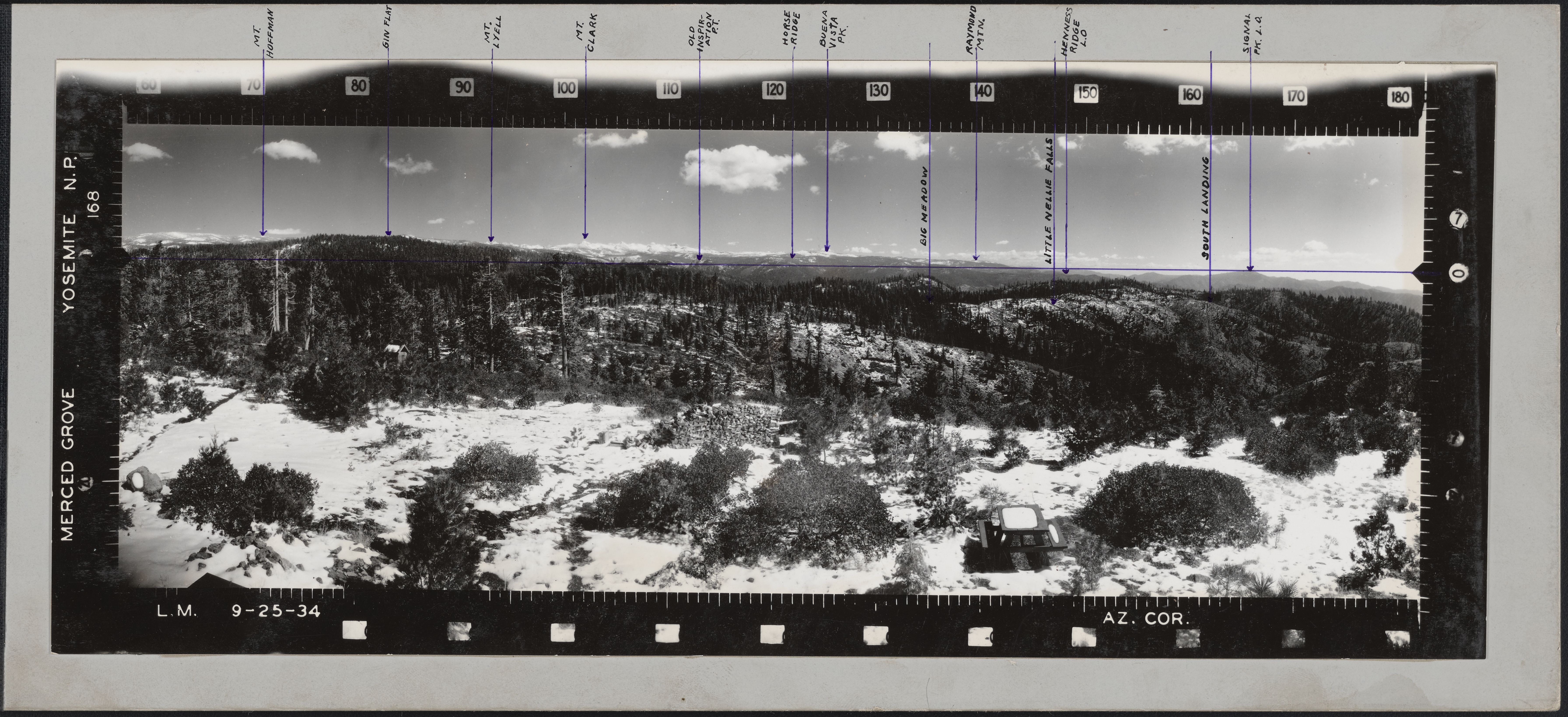
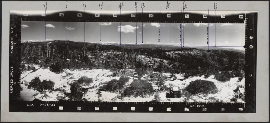
Merced Grove
Names of locations visible in this photograph are: Mt. Hoffman, Gin Flat, Mt. Lyell, Mt. Clark, Old Inspiration P.T., Horse Ridge, Buen Vista PK., Raymond Mtn., Henness Ridge L.O., Signal PK. L.O. Names written here indicates location hidden by
intervening topography are: Big Meadow, Little Nellie Falls, and South Landing
National Park Service
Permission must be secured from the individual copyright owners to reproduce any copyrighted materials contained within this website.
Public domain
Yosemite, (LCSH)
Image
Yosemite National Park, Code: YOSE
Merced Grove
Latitude: 37.749444, Longitude: -119.837222
Latitude: 37.749444, Longitude: -119.837222
Local Park number : ucm_yose6386_mercedgrove_001_003
9/1/2017 12:00:00 AM
01/01/1935 - 12/30/1935
panoramic photograph; tri-fold; right; has markings and titles. 40.5 x 17.5 cm (third of ucm_ucce_yose6386_mercedgrove_001_001and ucm_ucce_yose6386_mercedgrove_001_002)
Image
Public Can View
Organization: UC Merced
Address: Yosemite National Park Archives, 5083 Foresta Road, El Portal, CA 95318
Address: Yosemite National Park Archives, 5083 Foresta Road, El Portal, CA 95318
Friday, January 19, 2018 3:08:46 PM
Friday, January 19, 2018 3:08:46 PM
ucm_yose6386_mercedgrove_001_003.tif
Phase One Phase One, IQ150
1/45 sec
ISO 200
Friday, June 30, 2017 4:21:21 AM
tif
140.9 MB
Source: Series Description
Content: SERIES X: Panoramic Fire Lookout Photographs, 1934-1935, 1937. This series consists of a set of forty panoramic photographs taken from fire lookouts and lookout points (proposed lookout sights) in Yosemite National Park. Most photographs were taken in 1934, though a few date to 1937. They appear to be part of a U.S. Forest Service (USFS) project conducted around this time, although scant documentation about the photographs and about the USFS project exists in the National Park Service (NPS) archives. Accompanying the images is a letter to Superintendent C.G. Thomson of Yosemite National Park, dated 1935 and signed by the project photographer, Lester M. Moe, USFS forester/photographer. The letter lists the panoramic photographs to be donated to a variety of Yosemite locations and is paired with a distribution list that outlines the specific photographs to be given to each ranger station, office, and lookout in Yosemite National Park and in Sierra and Stanislaus National Forests. The letter and envelope mention enclosed vertical angle scales (to assist with image viewing), but these are not present in the collection. Lookout points in Yosemite National Park contemporaneous with these photographs were the Merced Grove (Crane Flat) Lookout, Aspen Valley Lookout, Henness Ridge, Signal Peak, Pilot Peak, Smith Peak, Sentinel Dome, Bald Mountain, Wawona Point, and Wood’s Ridge.
Source: Physical Description
Content: The majority of the photographs are tri-fold, mounted on heavy cardboard, and marked with tabs identifying the vantage point. The prints often contain information such as date, photographer’s initials (L.M.), and location. The photographs were originally housed in a green wooden box specifically designed for these images, stenciled “Panoramic Photographs.”
Source: Extended Description
Content: These photographs provide excellent documentation of Yosemite’s topography in the 1930s. Covering 120 degrees of the horizon, they were utilized for many decades by Yosemite lookouts to accurately locate forest fires. Today, in addition to conveying information about historic road and trail locations, changes in vegetation and landscape, and geomorphology, they provide a visual juxtaposition to later photographs that is useful for a variety of scientific, management, and administrative purposes.
Historic