Select Item below to DOWNLOAD - Once item is selected, right click and choose 'save as'
49938018-7352-46f7-9ee0-ef59e79635d8
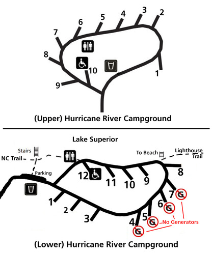
Hurricane River Campground Map
Hurricane River Campground map showing site numbers and locations.
Hurricane River Campground site map
Permission must be secured from the individual copyright owners to reproduce any copyrighted materials contained within this website. Digital assets without any copyright restrictions are public domain.
NPS
Public domain:Full Granting Rights
Image
Pictured Rocks National Lakeshore, Code: PIRO
Pictured Rocks National Lakeshore, Alger County, Michigan
Latitude: 46.513500213623, Longitude: -86.4669036865234
Latitude: 46.513500213623, Longitude: -86.4669036865234
03/22/2019
03/22/2019
Public Can View
Friday, March 22, 2019 12:59:16 PM
Friday, March 22, 2019 12:59:16 PM
PicturedRocksNL- Hurricane Campground Map.jpg
Friday, March 22, 2019 7:23:59 PM
jpg
203.1 kB
Scenic