Select Item below to DOWNLOAD - Once item is selected, right click and choose 'save as'
469f8161-6ade-43c7-bcf5-f55ab1c3c1dd
PMIS 207520 - Figures related to a proposal on changing hydrologic flows and the vulnerability of park roads and trails
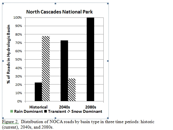
Three images are attached : a flow chart of access vulnerability , a bar graph looking at park roads by basin type, and a photo of Cascade River Road after a thunder storm.
NOCA Roads by Basin Type
Permission must be secured from the individual copyright owners to reproduce any copyrighted materials contained within this website. Digital assets without any copyright restrictions are public domain.
Public domain
Image
North Cascades National Park, Code: NOCA
North Cascades National Park - Cascade Rive Road, August 11, 2013, North Cascades National Park, Washington
Latitude: 48.8278884887695, Longitude: -121.35050201416
Latitude: 48.8278884887695, Longitude: -121.35050201416
08/11/2013
Public Can View
Monday, January 13, 2014 4:53:45 PM
Wednesday, August 9, 2017 6:41:45 PM
NOCA-5069b4eb285149c0b3a642d6e6a73597.jpg
Monday, January 1, 0001 12:00:00 AM
jpg
119.9 kB
Inventory
,
Budget