Select Item below to DOWNLOAD - Once item is selected, right click and choose 'save as'
3f2e6c21-6099-401b-9926-414d9a8f36f1
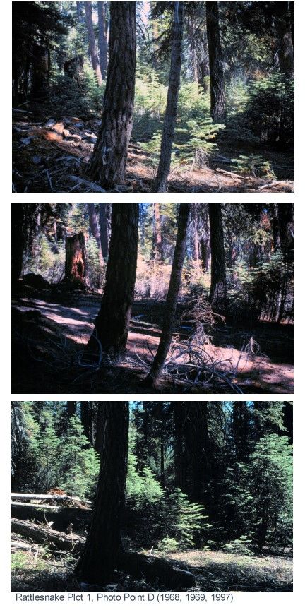
Fire plots revisited after 30 years in Kings Canyon backcountry, Sequoia and Kings Canyon National Parks, 1968-1997
explain who, what, where, when, why, and how
U.S. National Park Service
Permission must be secured from the individual copyright owners to reproduce any copyrighted materials contained within this website. Digital assets without any copyright restrictions are public domain.
Public domain
Fire research, ()
Image
Sequoia and Kings Canyon National Parks, Code: SEKI
Middle Fork Kings River, Sequoia and Kings Canyon National Parks, Fresno County, California
Latitude: 36.9809913635254, Longitude: -118.726501464844
Latitude: 36.9809913635254, Longitude: -118.726501464844
Legacy NPS Focus Record ID : 232377
03/09/2005
01/01/1968 - 12/30/1997
Digital camera image (TIF; 1.07 MB; 432 x 864; 71 dpi; 24 bit color)
Public Can View
Wednesday, March 9, 2005 3:24:09 PM
Wednesday, August 9, 2017 5:57:02 PM
rc_pl1d_comp_s382_lr.tif
Monday, January 1, 0001 12:00:00 AM
tif
169.7 kB
Events
Fire plots revisited after 30 years in Kings Canyon backcountry, Sequoia and Kings Canyon National Parks, 1968-1997
Fire plots revisited after 30 years in Kings Canyon backcountry, Sequoia and Kings Canyon National Parks, 1968-1997
Fire plots revisited after 30 years in Kings Canyon backcountry, Sequoia and Kings Canyon National Parks, 1968-1997
Fire plots revisited after 30 years in Kings Canyon backcountry, Sequoia and Kings Canyon National Parks, 1968-1997