Select Item below to DOWNLOAD - Once item is selected, right click and choose 'save as'
3cc23744-72f9-43cc-ad5a-051f2ea2a9f3
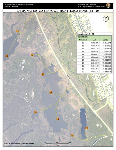
(12-20) Bodie Island Waterfowl Hunting Areas
Location map of Bodie Island waterfowl hunting areas 12-20.
Location map of Bodie Island waterfowl hunting areas 12-20.
Permission must be secured from the individual copyright owners to reproduce any copyrighted materials contained within this website. Digital assets without any copyright restrictions are public domain.
National Park Service
Public domain:Full Granting Rights
Image
Cape Hatteras National Seashore, Code: CAHA
Cape Hatteras National Seashore, North Carolina
Latitude: 35.2368392944336, Longitude: -75.6029281616211
Latitude: 35.2368392944336, Longitude: -75.6029281616211
01/01/0001
Friday, December 13, 2019 5:02:15 AM
Friday, December 13, 2019 5:02:15 AM
BI Designated Waterfowl Hunt Locs 12-20.jpg
Monday, January 1, 0001 12:00:00 AM
jpg
9.2 MB
Scenic