Select Item below to DOWNLOAD - Once item is selected, right click and choose 'save as'
3a392dc9-e438-4ab7-80d9-b43bdc1457f8
Mixed Conifer Forest Plant Community, on West Fork Soda Creek. Type Map. Right of two panel panorama.
SEKI Historic Image
Mixed Conifer Forest Plant Community, on West Fork Soda Creek. Type Map. Right of two panel panorama.
National Park Service
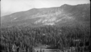
H.N. Marion, 361005, Quinn Ranger Station area, SNP, Mixed Conifer Forest Plant Community, on West Fork Soda Creek. Type Map. Right of two panel panorama.
Permission must be secured from the individual copyright owners to reproduce any copyrighted materials contained within this website. Digital assets without any copyright restrictions are public domain.
Public domain
Image
Quinn Ranger Station area, Tulare County, California
10/05/1936
option 1
Public Can View
Tuesday, January 10, 2017 1:04:01 PM
Tuesday, January 10, 2017 1:04:01 PM
08161.tif
Monday, January 1, 0001 12:00:00 AM
tif
13.5 MB
Scenic
,
Historic