Select Item below to DOWNLOAD - Once item is selected, right click and choose 'save as'
3a3558bf-f2c5-46b0-836a-8bda2ac5e1d4
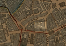
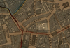
Map of downtown Boston (Cornhill area)
Map of downtown Boston, with a selection of buildings on Cornhill highlighted.
Map of downtown Boston, with a selection of buildings on Cornhill highlighted.
Boston Slatter Map, 1852
Public domain
Image
Boston African American National Historic Site, Code: BOAF
Boston African American National Historic Site, Suffolk County, Massachusetts
Latitude: 42.3578987121582, Longitude: -71.0706024169922
Latitude: 42.3578987121582, Longitude: -71.0706024169922
01/01/1852
09/03/2020
Public Can View
Thursday, September 3, 2020 1:33:18 PM
Thursday, September 3, 2020 1:33:18 PM
SFM4-Cornhill.jpg
Thursday, September 3, 2020 8:43:31 PM
jpg
327.4 kB
Historic
,
Map