Select Item below to DOWNLOAD - Once item is selected, right click and choose 'save as'
39edef5f-0f32-459b-a8f1-c0fbbe5a62c6
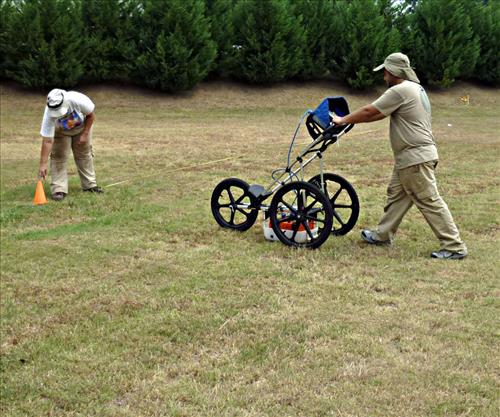
Recording Historic Cemeteries - GPR survey of the Burnett Tract Slave Cemetery
SEAC archeologists push a ground penetrating radar unit over the suspected location of the slave cemetery in order to peek into the ground.
Permission must be secured from the individual copyright owners to reproduce any copyrighted materials contained within this website. Digital assets without any copyright restrictions are public domain.
Public domain
Image
Blue Ridge Parkway, Code: BLRI
ANCS : SEAC-02030
02/23/2017
12/08/2015
Southeast Archeological Center archives
For a public web map
Public Can View
Person: Jill Halchin
Organization: National Park Service
Position: GIS Coordinator
Address: Southeast Archeological Center
Email: jill_halchin@nps.gov
Organization: National Park Service
Position: GIS Coordinator
Address: Southeast Archeological Center
Email: jill_halchin@nps.gov
Thursday, February 23, 2017 11:33:55 AM
Wednesday, August 9, 2017 5:28:47 PM
GPR.jpg
Panasonic Panasonic, DMC-ZR1
10/6400 sec at f / 3.3
4.5 mm
ISO 80
Wednesday, August 24, 2011 9:35:57 PM
jpg
310.0 kB
Museum