Select Item below to DOWNLOAD - Once item is selected, right click and choose 'save as'
372c43f7-a695-4740-9dc4-bb5fa70f3545
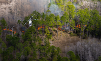
Surface fire during Northeast prescribed fire
Aerial view of helicopter above surface fire burning in pines.
A helicopter flies over the Northeast prescribed fire in Everglades National Park.
The Northeast project area of EVER is located in the northeast corner of Everglades National Park. The project area is bordered by two major road corridors, Tamiami Trail (U.S. Highway 41) to the North and Krome Avenue to the East.
Wildland Fire Spread and Suppression
Public Domain
NPS/Michael Gue
Public domain:Full Granting Rights
Image
Fire and Aviation Management Program, Code: FIRE
Everglades National Park, Florida
Latitude: 25.2717704772949, Longitude: -80.953498840332
Latitude: 25.2717704772949, Longitude: -80.953498840332
01/19/2022
01/19/2022
Public Can View
NPS/Michael Gue
Wednesday, July 9, 2025 8:50:43 PM
Wednesday, July 9, 2025 9:28:04 PM
EVER-NortheastRx-NPS-MichaelGue-202206.jpg
SONY SONY, ILCE-7RM4A 125, FE 70-200mm F2.8 GM OSS
1/6400 sec at f / 2.8
200 mm
ISO 125
Wednesday, January 19, 2022 12:24:36 AM
jpg
2.6 MB
Scenic