Select Item below to DOWNLOAD - Once item is selected, right click and choose 'save as'
34075e45-4cb7-46dd-9c9d-a13e5a194b4f
Aquifer System
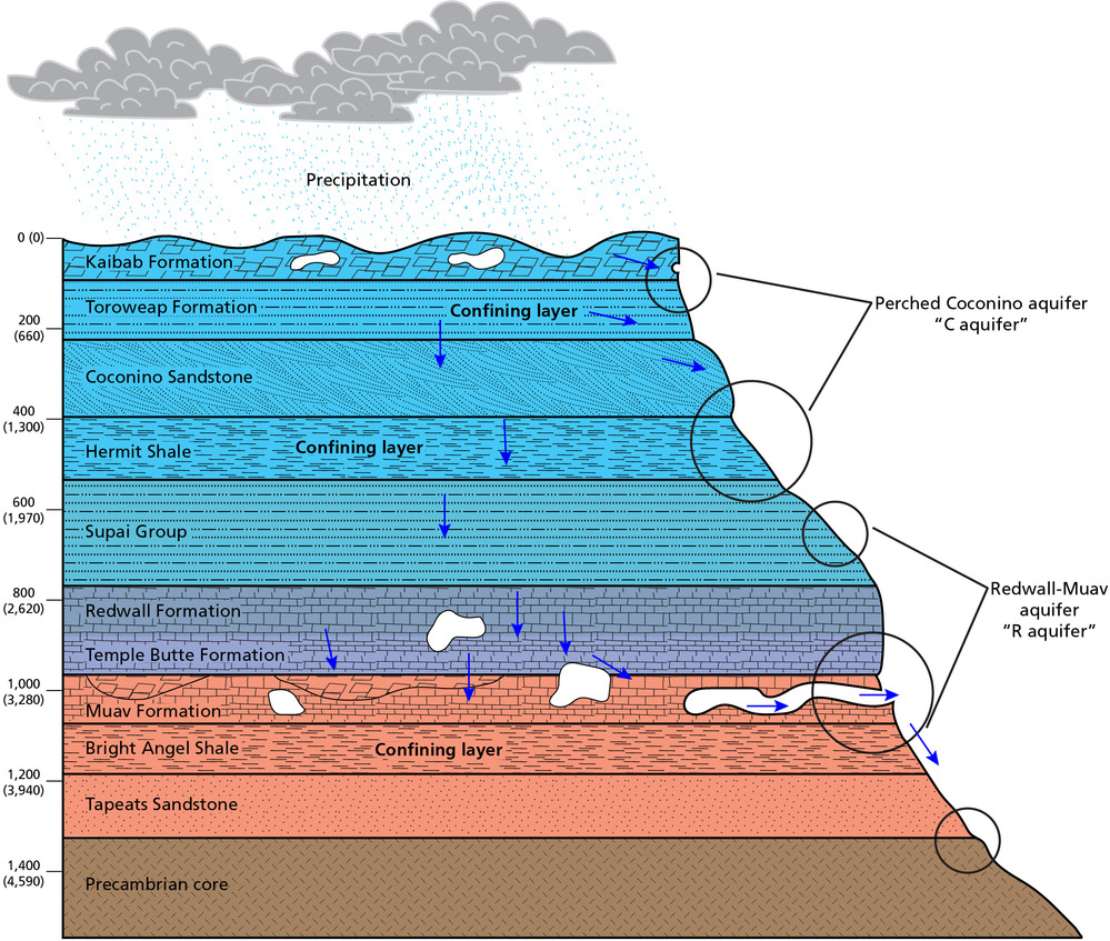
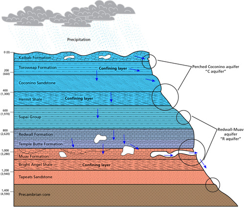
Hydro-stratigraphic schematic profile of the aquifer system in Grand Canyon National Park. The profile shows the layers of rock strata, faults, and location of springs. The three confining layers are the (top to bottom: Toroweap Formation, Hermit Shale, and Bright Angle Shale). The perched Coconino (“C”) aquifer is in the Coconino Sandstone between the Toroweap and Hermit. Springs are adjacent to the confining layers. The Redwall-Muav (“R”) aquifer is between the Hermit and Bright Angel. Large springs are in the Muav above the Bright Angel.
Hydro-stratigraphic schematic profile of the aquifer system in Grand Canyon National Park.
Faults (blue lines) serve as vertical conduits for groundwater. Large circles represent the dominant location of springs. Smaller circles represent additional locations of springs. The three confining layers represent relatively thick zones of impermeable rock.
Permission must be secured from the individual copyright owners to reproduce any copyrighted materials contained within this website. Digital assets without any copyright restrictions are public domain.
Graphic by Trista Thornberry-Ehrlich (Colorado State University), modified from Jones et al. (2017a) and Tobin et al. (2018)
Public domain:Full Granting Rights
Image
Grand Canyon National Park, Code: GRCA
Grand Canyon National Park, Arizona
Latitude: 36.3291397094727, Longitude: -112.790603637695
Latitude: 36.3291397094727, Longitude: -112.790603637695
01/01/0001
Public Can View
Friday, June 4, 2021 2:26:24 PM
Friday, June 4, 2021 2:26:24 PM
GRCA_46.jpg
Monday, January 1, 0001 12:00:00 AM
jpg
2.7 MB
Scenic