Select Item below to DOWNLOAD - Once item is selected, right click and choose 'save as'
313a8d09-2214-4054-bccb-057a6b4f2ba2
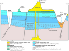
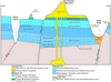
Generalized Cross Section Between the Verde Valley and Grand Canyon.
Cross-section diagram of the geology between Verde Valley and the Grand Canyon. Diagram primarily consists of sub-horizontal sedimentary rock units cut by faults. A basaltic unit cuts vertically through the units between Grand Canyon and Verde Valley, and forms a mountain on the surface.
Investigators have correlated the rocks exposed in the Verde Valley with the rocks in the Grand Canyon region. The Great Unconformity—perhaps the world’s most famous—is a distinctive feature in the Verde
Valley’s rock record. The Great Unconformity is commonly recognized by its appearance (and excellent exposure) at the bottom of the Grand Canyon. Five-hundred-million-year-old (Cambrian) Tapeats Sandstone is above the unconformity; 1.75-billion-year-old (Proterozoic) gneiss (a metamorphic rock
with alternating bands of dark and light minerals) is below the unconformity. In the Verde Valley, the Great Unconformity represents a 1.2-billion-year-long “gap” in the geologic record. Montezuma Castle
National Monument is in the Beaver Creek–Wet Beaver Creek tributary canyon of the Verde Valley. Wet Beaver Creek cuts into the Schnebly Hill, Hermit, and Verde Formations, as well as basalt upstream from
the monument. The Redwall Limestone is a source of groundwater to Montezuma Well.
Permission must be secured from the individual copyright owners to reproduce any copyrighted materials contained within this website. Digital assets without any copyright restrictions are public domain.
Graphic by Trista Thornberry-Ehrlich (Colorado State University) after Blasch et al. (2005, figure 23)
Public domain:Full Granting Rights
Image
Montezuma Castle National Monument, Code: MOCA
Montezuma Castle National Monument, Yavapai County, Arizona
Latitude: 34.6110000610352, Longitude: -111.83699798584
Latitude: 34.6110000610352, Longitude: -111.83699798584
01/01/0001
Public Can View
Wednesday, July 7, 2021 5:24:10 PM
Wednesday, July 7, 2021 5:24:10 PM
8.jpg
Monday, January 1, 0001 12:00:00 AM
jpg
1.5 MB
Scenic