Select Item below to DOWNLOAD - Once item is selected, right click and choose 'save as'
2f79fc81-c035-4598-b06f-8aea5aa76d9b
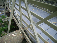
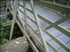
Hurricane Irene Damage to the Hornbecks McDade Trail Bridge in August 2011
Damage to the Hornbecks McDade Trail Bridge caused by Hurricane Irene August 2011
Damage to the Hornbecks McDade Trail Bridge
(C) Caplio 500SE User
Public domain
Image
Delaware Water Gap National Recreation Area, Code: DEWA
Delaware Water Gap National Recreation Area
Latitude: 41.1003189086914, Longitude: -74.9569320678711
Latitude: 41.1003189086914, Longitude: -74.9569320678711
09/04/2011
09/02/2011
Public Can View
Wednesday, November 2, 2011 10:03:57 AM
Wednesday, August 9, 2017 4:07:07 PM
DEWA-a7526ee85ba14eef94de1bcc05db3ed0.jpg
RICOH RICOH, Caplio 500SE
1/203 sec at f / 2.5
5.8 mm
ISO 64
Sunday, September 4, 2011 2:57:30 PM
jpg
2.6 MB
Monitoring
,
Inventory
,
Budget