Select Item below to DOWNLOAD - Once item is selected, right click and choose 'save as'
2f6cbcf0-4dfa-4e09-a624-3aa934454611
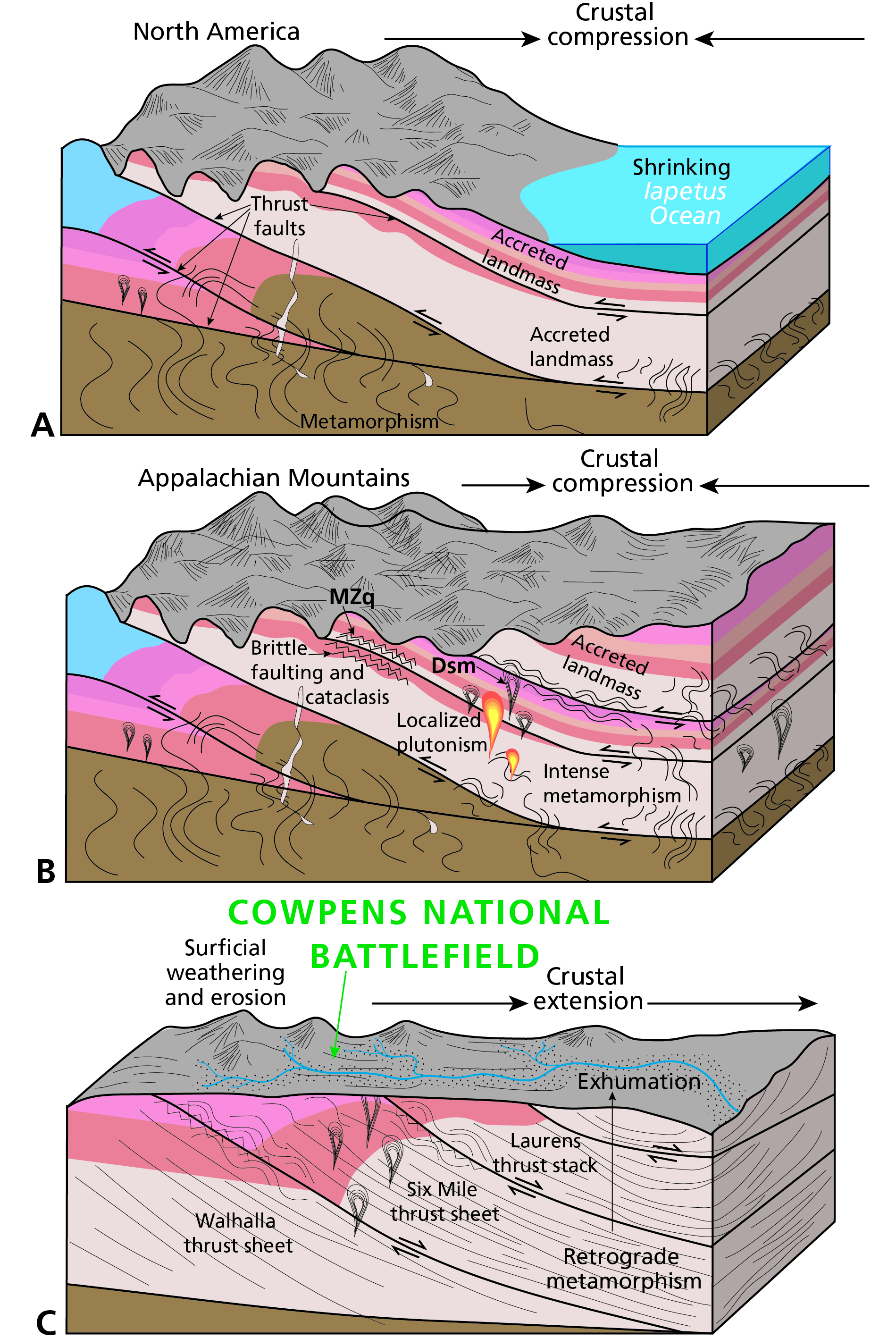
Illustration of the Evolution of the Landscape and Geologic Foundation of Cowpens National Battlefield.
Figure 7A–C. Schematic graphics illustrating the evolution of the Cowpens National Battlefield landscape, continued. Three graphics depict three periods and events in geologic time that gave rise to the rocks and landforms at the park today. Caption follows.
Figure 7A–C. Illustration of the evolution of the landscape and geologic foundation of Cowpens National Battlefield. (A) In the Ordovician and Silurian, periodic collisions of volcanic arcs and microcontinents were building out the eastern margin of Laurentia. (B) By the Pennsylvanian, major continental collision pushed the Appalachians up to their highest point and all the accreted landmasses and thrust sheets were deformed and metamorphosed. (C) Since the Triassic, when the landmasses began to break apart, the landscape at Cowpens National Battlefield
has been subjected to continuous weathering and erosion. Sediments are transported eastward to become part of the Coastal Plain. Graphics are not to scale. Colors are standard colors approved by the US Geological Survey to indicate different time periods on geologic maps and correspond to the colors on the geologic time scale. Map symbols are included for the geologic map units in the GRI
GIS data.
Permission must be secured from the individual copyright owners to reproduce any copyrighted materials contained within this website. Digital assets without any copyright restrictions are public domain.
Graphic by Trista L. Thornberry-Ehrlich
(Colorado State University) with information from Bobyarchick et al. (1988), Barineau et al. (2015), and GRI GIS source data.
Public domain:Full Granting Rights
Image
Cowpens National Battlefield, Code: COWP
Cowpens National Battlefield, Cherokee County, South Carolina
Latitude: 35.1315002441406, Longitude: -81.8093032836914
Latitude: 35.1315002441406, Longitude: -81.8093032836914
01/01/0001
Public Can View
Wednesday, May 12, 2021 10:32:35 AM
Wednesday, May 12, 2021 10:32:35 AM
COWP_07.jpg
Monday, January 1, 0001 12:00:00 AM
jpg
3.4 MB
Scenic