Select Item below to DOWNLOAD - Once item is selected, right click and choose 'save as'
2ee6ee18-8c58-4c63-b369-8f40781b3593
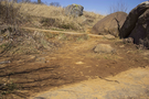
Erosion at Devil’s Den
This is a view of unhealthy and eroded soil. The center of the frame is full of dark brown earth with small rocks little plant life. Ahead is a dirt path leading to two large boulders on the right. Past the path is tall dark grass in contrast to the barren region in the center.
A view of the effects of erosion on the soil at Devil’s Den.
Permission must be secured from the individual copyright owners to reproduce any copyrighted materials contained within this website. Digital assets without any copyright restrictions are public domain.
NPS Photo
Public domain:Full Granting Rights
Image
Gettysburg National Military Park, Code: GETT
Gettysburg National Military Park, Adams County, Pennsylvania
Latitude: 39.804500579834, Longitude: -77.2384033203125
Latitude: 39.804500579834, Longitude: -77.2384033203125
03/16/2022 | Wednesday, March 16, 2022
03/16/2022
Public Can View
Friday, April 29, 2022 8:06:15 PM
Wednesday, May 11, 2022 8:58:46 PM
Jason_3-16-22_0014 copy.jpg
Canon Canon, Canon EOS 60D 100, EF-S18-200mm f/3.5-5.6 IS
1/800 sec at f / 4
24 mm
ISO 100
Wednesday, March 16, 2022 1:40:05 PM
jpg
1.2 MB
Scenic