Select Item below to DOWNLOAD - Once item is selected, right click and choose 'save as'
2ad3e839-63ff-45f7-8212-652d28c06a43
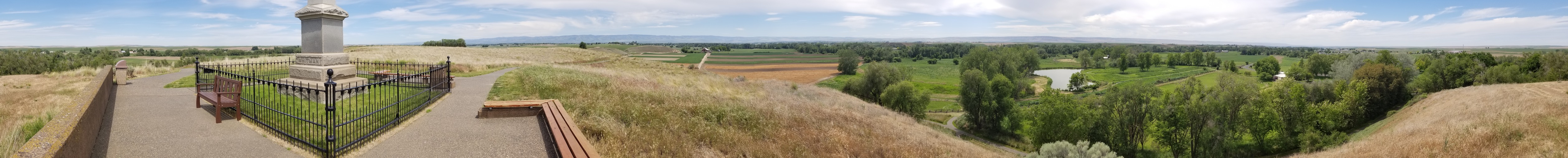
Whitman Mission 360 Panoramic View
the base of a monument in the foreground followed by yellow agricultural fields in the background with mountains beyond. To the left, fields of green tall grass and trees with a pond.
A 360 degree panoramic view from Monument Hill.
Permission must be secured from the individual copyright owners to reproduce any copyrighted materials contained within this website. Digital assets without any copyright restrictions are public domain.
NPS Photo
Public domain:Full Granting Rights
Image
Whitman Mission National Historic Site, Code: WHMI
Whitman Mission National Historic Site, Walla Walla County, Washington
Latitude: 46.0427017211914, Longitude: -118.464996337891
Latitude: 46.0427017211914, Longitude: -118.464996337891
05/28/2020
05/28/2020
Public Can View
Saturday, August 1, 2020 4:46:58 PM
Saturday, August 1, 2020 4:46:58 PM
Hilltop 360 (2) cropped.jpg
samsung samsung, SM-N950U1
4.3 mm
Thursday, May 28, 2020 7:52:36 PM
jpg
11.9 MB
Scenic