Select Item below to DOWNLOAD - Once item is selected, right click and choose 'save as'
278d5a8834e8404b825bc120884c2f97
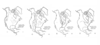
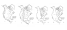
Maps of the United States and Central America depicts the Atlantic Flyway, Mississippi Flyway, Central Flyway, and Pacific Flyway.
Maps of the United States and Central America depicts the Atlantic Flyway, Mississippi Flyway, Central Flyway, and Pacific Flyway.
Illustration is made up of one base map with four overlays for each flyway, but imaged as if it were one illustration.; Abbr=EX
U.S. National Park Service
Project=Roaches Run Waterfowl Sanctuary; Reflective Art
Government owns art and all reproduction rights.
Public domain
Image
NPS-wide, Code: NPS
Image Management System : IMS 10651
20190904
Illustration is made up of one base map with four overlays for each flyway, but imaged as if it were one illustration.
P6
Public Can View
Organization: Harpers Ferry Center
Address: Harpers Ferry Center, 67 Mather Place, Harpers Ferry, WV, 25425, 304-535-5050
Address: Harpers Ferry Center, 67 Mather Place, Harpers Ferry, WV, 25425, 304-535-5050
Friday, October 4, 2019 11:50:33 AM
Friday, October 4, 2019 11:50:33 AM
10651.jpg
jpg
44.4 kB
Museum