Select Item below to DOWNLOAD - Once item is selected, right click and choose 'save as'
2647C262-0B98-DEBC-DD7DA9E0E8C73D5B
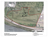
Fort Vancouver Cultural Landscape
A red line encircles the features of the fort landscape on a map, marking the boundary.
Fort Vancouver. A closer look at the boundary of the Fort Vancouver component landscape identifies some of the reconstructed features that suggest the historic landscape, including the fort stockade, garden, orchard, houses in the HBC village, and surrounding agricultural fields.
U.S. National Park Service
Permission must be secured from the individual copyright owners to reproduce any copyrighted materials contained within this website. Digital assets without any copyright restrictions are public domain.
NPS, 2009
Public domain:Full Granting Rights
Image
Fort Vancouver National Historic Site, Code: FOVA
45.62290, -122.66432
Fort Vancouver National Historic Site
Latitude: 45.623851776123, Longitude: -122.662101745605
Fort Vancouver National Historic Site
Latitude: 45.623851776123, Longitude: -122.662101745605
Public Can View
Wednesday, September 12, 2018 12:44:26 PM
Wednesday, September 12, 2018 12:44:26 PM
264C3815-B5C3-3A9D-5FB06B18DDFF1D06.jpg
Thursday, July 23, 2015 10:14:59 PM
jpg
225.2 kB
Scenic