Select Item below to DOWNLOAD - Once item is selected, right click and choose 'save as'
25ae983fbf1c401788f83642ff43188c
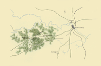
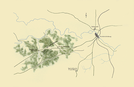
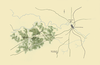
Map showing area known as The Wilderness where General Robert E. Lee and General Ulysses S. Grant fought on May 5-6, 1864.
Map showing area known as The Wilderness where General Robert E. Lee and General Ulysses S. Grant fought on May 5-6, 1864.
Abbr=AVA
U.S. National Park Service
Reflective Art
Government owns art and all reproduction rights.
Public domain
Image
Fredericksburg and Spotsylvania National Military Park, Code: FRSP
Fredericksburg and Spotsylvania National Military Park, Virginia
Latitude: 38.2948608398438, Longitude: -77.7218475341797
Latitude: 38.2948608398438, Longitude: -77.7218475341797
Image Management System : IMS 01293
20190904
Image_Size=W: 35 7/8" x H: 24"; Metric_Size=W: 88.83CM X H: 60.91CM; AVA Project #66, Plate 6
MC V5
Public Can View
Organization: Harpers Ferry Center
Address: Harpers Ferry Center, 67 Mather Place, Harpers Ferry, WV, 25425, 304-535-5050
Address: Harpers Ferry Center, 67 Mather Place, Harpers Ferry, WV, 25425, 304-535-5050
Monday, October 7, 2019 3:05:22 PM
Monday, October 7, 2019 3:05:22 PM
01293.jpg
jpg
176.9 kB
Museum