Select Item below to DOWNLOAD - Once item is selected, right click and choose 'save as'
1c615b43bd644cdea0e1c03051a1907d
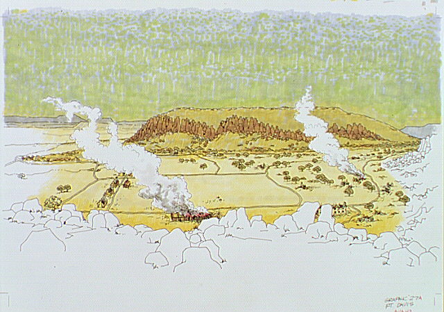
View from distance of burning buildings at Fort Davis.
View from distance of burning buildings at Fort Davis.
Illustration not used in Fort Davis NHS audiovisual program.; Abbr=AVA
U.S. National Park Service
Reflective Art
Government owns art and all reproduction rights.
Public domain
Color felt tip markers, (HFC ArtMedium)
Image
Fort Davis National Historic Site, Code: FODA
Fort Davis National Historic Site, Jeff Davis County, Texas
Latitude: 30.5993003845215, Longitude: -103.896003723145
Latitude: 30.5993003845215, Longitude: -103.896003723145
Image Management System : IMS 01285
20190904
01/01/1979 - 12/30/1979
Image_Size=W: 23" x H: 16 3/4"; Metric_Size=W: 58.38CM X H: 40.61CM; AVA Project #43; Slide Show #252, Plate 27A
B8
Public Can View
Organization: Harpers Ferry Center
Address: Harpers Ferry Center, 67 Mather Place, Harpers Ferry, WV, 25425, 304-535-5050
Address: Harpers Ferry Center, 67 Mather Place, Harpers Ferry, WV, 25425, 304-535-5050
Thursday, October 3, 2019 6:34:27 PM
Thursday, October 3, 2019 6:34:27 PM
01285.JPG
jpg
85.8 kB
Museum