Select Item below to DOWNLOAD - Once item is selected, right click and choose 'save as'
19a38faf-3f54-4457-9736-f3565189d736
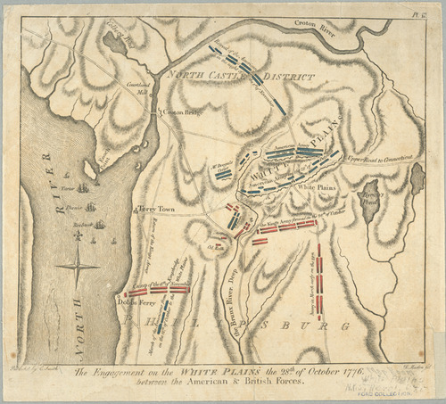
The engagement on the White Plains, the 28th of October 1776
Map of the terrain of White Plains, New York with red and blue markings.
Map depiction of the Battle of White Plains between the American and British forces, represented by blue and red markings, respectively. Occurred on October 28, 1776.
C. Smith
This map image is used for the Luther Jotham (Patriot of Color) story map.
The New York Public Library states there are no known restrictions. See this url for more information: https://digitalcollections.nypl.org/items/510d47da-f073-a3d9-e040-e00a18064a99
Map Division, The New York Public Library, Astor, Lenox and Tilden Foundation
Public domain:New York Public Library states there are no known restrictions.
Image
Boston National Historical Park, Code: BOST
Boston National Historical Park, Suffolk County, Massachusetts
Latitude: 42.3734016418457, Longitude: -71.0557022094727
Latitude: 42.3734016418457, Longitude: -71.0557022094727
https://digitalcollections.nypl.org/items/510d47da-f073-a3d9-e040-e00a18064a99
01/01/1796
06/28/2006
Map Division, The New York Public Library, Astor, Lenox and Tilden Foundation
Organization: New York Public Library
Wednesday, January 19, 2022 8:56:54 AM
Wednesday, January 19, 2022 9:02:30 AM
White Plains.jpg
Wednesday, June 28, 2006 10:48:20 PM
jpg
621.1 kB
Historic