Select Item below to DOWNLOAD - Once item is selected, right click and choose 'save as'
18a2bff7-8102-421f-9507-2c1b75ba6c1e
Basement Rocks
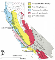
Map of California basement rocks.
Map of California basement rocks. The basement rocks
in the area of the park—the Great Valley sequence, the Franciscan
assemblage (the Franciscan Complex), and Mesozoic granitic rocks
(the Salinian complex)—formed in geologic settings associated with
an ancient subduction zone (fig. 4). This figure shows the location
of the rocks in California today
Permission must be secured from the individual copyright owners to reproduce any copyrighted materials contained within this website. Digital assets without any copyright restrictions are public domain.
US Geological Survey graphic by
Irwin (1990, fig. 3.3).
Public domain:Full Granting Rights
Image
Fort Point National Historic Site, Code: FOPO
Golden Gate National Recreation Area, Code: GOGA
Muir Woods National Monument, Code: MUWO
Golden Gate National Recreation Area, Code: GOGA
Muir Woods National Monument, Code: MUWO
Fort Point National Historic Site, San Francisco County, California
Latitude: 37.8084983825684, Longitude: -122.473999023438
Golden Gate National Recreation Area, California
Latitude: 37.8916893005371, Longitude: -122.635803222656
Muir Woods National Monument, Marin County, California
Latitude: 37.8983993530273, Longitude: -122.583999633789
Latitude: 37.8084983825684, Longitude: -122.473999023438
Golden Gate National Recreation Area, California
Latitude: 37.8916893005371, Longitude: -122.635803222656
Muir Woods National Monument, Marin County, California
Latitude: 37.8983993530273, Longitude: -122.583999633789
01/01/0001
Public Can View
Monday, September 6, 2021 9:28:51 AM
Monday, September 6, 2021 10:39:08 AM
05_GOGA_CA_Basement_Irwin_1990_annotated-01.jpg
Monday, January 1, 0001 12:00:00 AM
jpg
743.8 kB
Scenic