Select Item below to DOWNLOAD - Once item is selected, right click and choose 'save as'
17794555-01c8-4d27-b3b9-89d6cb7f1b34
~ai-4486fe8c-9323-419e-8d12-21aa2806a366_
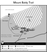
Trail map of Mt. Baldy showing the sections currently closed.
Trail map of Mt. Baldy showing the sections currently closed.
Permission must be secured from the individual copyright owners to reproduce any copyrighted materials contained within this website. Digital assets without any copyright restrictions are public domain.
NPS
Public domain:Full Granting Rights
Image
Indiana Dunes National Park, Code: INDU
Indiana Dunes National Park, Indiana
Latitude: 41.656120300293, Longitude: -87.0431137084961
Latitude: 41.656120300293, Longitude: -87.0431137084961
01/01/0001
Public Can View
Monday, January 31, 2022 9:15:38 AM
Monday, January 31, 2022 12:16:47 PM
Mount-Baldy-Beach-Trail-Map-2020.jpg
Monday, January 1, 0001 12:00:00 AM
jpg
487.0 kB
Scenic