Select Item below to DOWNLOAD - Once item is selected, right click and choose 'save as'
16880c7e-a502-4cc0-aea7-4fc4533363cb
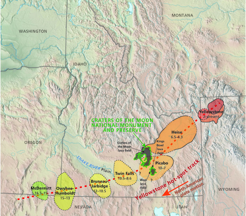
Map of the Yellowstone Hot-Spot Track.
Map of the Yellowstone hot-spot track.
The park is about 240 km (150 mi) southwest of Yellowstone National Park. The map highlights the Yellowstone hot-spot track, which is composed of seven volcanic fields. The hot spot remained stationary
as the North American plate moved to the southwest (arrow). The ages (in millions of years, on the figure) of the various volcanic fields indicate this progression, starting with the McDermitt volcanic field (approximately 16.5 million–15 million years ago) to the present location under Yellowstone. The park
area was situated over the hot spot between about 6.5 million and 4.3 million years ago. Heise Group (Th) rhyolitic rocks in the northern part of the park represent that period of time. Ages are from Smith and
Siegel (2000).
Permission must be secured from the individual copyright owners to reproduce any copyrighted materials contained within this website. Digital assets without any copyright restrictions are public domain.
Graphic by Trista Thornberry-Ehrlich (Colorado State University).
Public domain:Full Granting Rights
Image
Craters of the Moon National Monument and Preserve, Code: CRMO
Craters of the Moon National Monument and Preserve, Idaho
Latitude: 43.0189094543457, Longitude: -113.626800537109
Latitude: 43.0189094543457, Longitude: -113.626800537109
01/01/0001
Public Can View
Wednesday, July 21, 2021 3:06:42 PM
Wednesday, July 21, 2021 4:54:24 PM
Figure_4_CRMO_HotSpotTrack_0721-2017_tte-01 (1).jpg
Monday, January 1, 0001 12:00:00 AM
jpg
7.7 MB
Scenic