Select Item below to DOWNLOAD - Once item is selected, right click and choose 'save as'
1620bd53-211c-42dc-9bd9-951197219c80
Aleutian Earthquakes
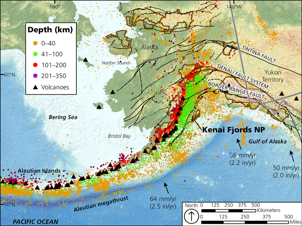
Map of earthquake epicenters greater than magnitude 3.0, colored by depth (1889 to present). The Aleutian arc volcanoes (black triangles) form above the subduction zone where the Pacific plate reaches a depth of 100 km (where the earthquake epicenters transition from red to purple). The Pacific plate motion is to the northwest at rates between 50 and 64 mm per year. Earthquake depths beneath Kenai Fjords National Park are primarily between 0 and 40 km.
Map of earthquake epicenters greater than magnitude 3.0, colored by depth (1889 to present). The Aleutian
arc volcanoes (black triangles) form above the subduction zone where the Pacific plate reaches a depth of 100 km
(where the earthquake epicenters transition from red to purple). The Pacific plate motion is shown with arrows. NPS
areas outlined in brown
Permission must be secured from the individual copyright owners to reproduce any copyrighted materials contained within this website. Digital assets without any copyright restrictions are public domain.
Earthquake data downloaded from http://www.aeic.alaska.edu
Public domain:Full Granting Rights
Image
Kenai Fjords National Park, Code: KEFJ
Kenai Fjords National Park, Kenai Peninsula Borough, Alaska
Latitude: 59.9532012939453, Longitude: -149.88200378418
Latitude: 59.9532012939453, Longitude: -149.88200378418
10/09/2017
10/09/2017
Public Can View
Monday, August 16, 2021 1:48:33 PM
Monday, August 16, 2021 4:00:29 PM
Fig_3_Aleutian_Earthquakes_KEFJ.jpg
Monday, October 9, 2017 5:00:17 PM
jpg
3.5 MB
Scenic