Select Item below to DOWNLOAD - Once item is selected, right click and choose 'save as'
15f948a5-f37d-41ac-97d1-b6917528610a
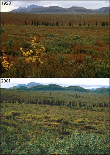
Changing Treelines at Teklanika River: 1958-2001
A photo pair showing Changing Treelines at Teklanika River: 1958-2001
In this remarkably matched photo pair, one can line up individual trees and see how successful they have been at reproducing! Taken off the park road along the Teklanika River, these photos capture a trend of increasing spruce across much of Denali's landscape. What physical controls do you think are loosening to allow this increase?
Original year: 1958; Rephoto year: 2001
U.S. National Park Service
Photos and photo pairs are pre-approved for educational use ONLY. To use them in educational products, credit them the same way as they are credited on the website, Photo Credit: Original photographer: Leslie A. Viereck; Rephoto photographer: Leslie A. Viereck. For any other use beyond education, contact Denali National Park and Preserve for additional copyright information on specific images of interest.
Original photographer: Leslie A. Viereck; Rephoto photographer: Leslie A. Viereck
Restrictions apply on use and/or reproduction
Image
Denali National Park and Preserve, Code: DENA
Teklanika River, Alaska Range mountains, Alaska
Latitude: 63.711625, Longitude: -149.511332
Denali National Park and Preserve, Alaska
Latitude: 63.3182792663574, Longitude: -150.602905273438
Latitude: 63.711625, Longitude: -149.511332
Denali National Park and Preserve, Alaska
Latitude: 63.3182792663574, Longitude: -150.602905273438
2012/06/25
Public Can View
Person: Digital Manager
Organization: US National Park Service
Address: Denali National Park and Preserve, P.O. Box 9, Denali Park, AK 99755
Organization: US National Park Service
Address: Denali National Park and Preserve, P.O. Box 9, Denali Park, AK 99755
Thursday, June 6, 2024 4:43:55 PM
Thursday, June 6, 2024 4:43:55 PM
LV_A214.jpg
jpg
294.2 kB
Scenic
,
Historic
,
Monitoring