Select Item below to DOWNLOAD - Once item is selected, right click and choose 'save as'
110ec576-1bd0-4cbc-a85e-71153464d67a
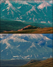
Human Development and Impacts at Nenana River: 1976-2005
A photo pair showing Human Development and Impacts at Nenana River: 1976-2005
This photo pair is an aerial view looking towards the Nenana River Canyon. These photos do not capture the entirety of the area, but show the large scar from the road cut ascending to hotels perched above the canyon. The development occurred not long after the completion of the George Parks Highway, connecting two of Alaska's major cities, Anchorage and Fairbanks. With increasing road traffic came increasing visitation to the park, and an increasing need for visitor services. Much of this development has occurred just outside the park boundaries, and is primarily concentrated in the dramatic Nenana River Canyon.
Original year: 1976; Rephoto year: 2005
U.S. National Park Service
Photos and photo pairs are pre-approved for educational use ONLY. To use them in educational products, credit them the same way as they are credited on the website, Photo Credit: Original photographer: Fred Dean; Rephoto photographer: Carl Roland. For any other use beyond education, contact Denali National Park and Preserve for additional copyright information on specific images of interest.
Original photographer: Fred Dean; Rephoto photographer: Carl Roland
Restrictions apply on use and/or reproduction
Image
Denali National Park and Preserve, Code: DENA
Nenana River, Alaska Range mountains, Alaska
Latitude: 63.742996, Longitude: -148.887183
Denali National Park and Preserve, Alaska
Latitude: 63.3182792663574, Longitude: -150.602905273438
Latitude: 63.742996, Longitude: -148.887183
Denali National Park and Preserve, Alaska
Latitude: 63.3182792663574, Longitude: -150.602905273438
2016/03/03
Public Can View
Person: Digital Manager
Organization: US National Park Service
Address: Denali National Park and Preserve, P.O. Box 9, Denali Park, AK 99755
Organization: US National Park Service
Address: Denali National Park and Preserve, P.O. Box 9, Denali Park, AK 99755
Thursday, June 6, 2024 4:51:52 PM
Thursday, June 6, 2024 4:51:52 PM
065557_22_magnified.jpg
jpg
299.2 kB
Scenic
,
Historic
,
Monitoring