Select Item below to DOWNLOAD - Once item is selected, right click and choose 'save as'
10f6b190-c0f5-448f-a207-10e758391630
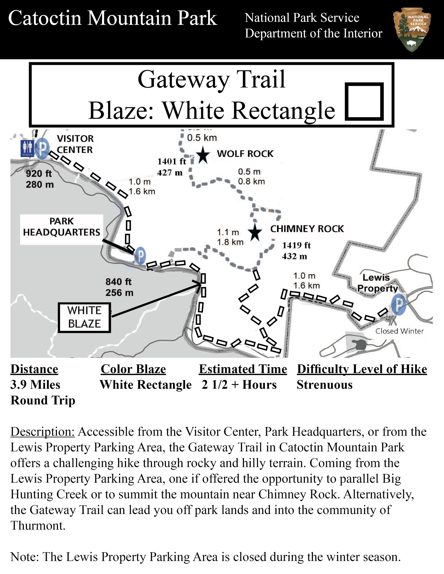
Gateway Trail
Map showing the hiking trail. The text on the map is as follows.
Trail Name: Gateway Trail, Distance: 3.9 Miles, Color of Blaze: White Rectangle, Estimate Time: 2 1/2+ Hours, Difficulty: Strenuous, Description: Accessible from the Visitor Center, Park Headquarters, or from the Lewis Property Parking Area, the Gateway Trail in Catoctin Mountain Park offers a challenging hike through rocky and hilly terrain. Coming from the Lewis Property Parking Area, one if offered the opportunity to parallel Big Hunting Creek or to summit the mountain near Chimney Rock. Alternatively, the Gateway Trail can lead you off park lands and into the community of Thurmont. Note: The Lewis Property Parking Area is closed during the winter season.
Permission must be secured from the individual copyright owners to reproduce any copyrighted materials contained within this website. Digital assets without any copyright restrictions are public domain.
National Park Service
Public domain:Full Granting Rights
Image
Catoctin Mountain Park, Code: CATO
Thurmont, Catoctin Mountain Park, Frederick County, Maryland
Latitude: 39.6501007080078, Longitude: -77.4636001586914
Latitude: 39.6501007080078, Longitude: -77.4636001586914
https://www.nps.gov/cato/planyourvisit/hiking.htm
10/16/2023 | Current as of October 16, 2023
10/16/2023
This map was the map on the official trails page for Catoctin Mountain Park's hiking page on October 16, 2023. Refer to the hiking trails page on NPS.gov or using the official NPS mobile app.
Public Can View
Person: Cynthia Wanschura
Organization: National Capital Region, National Park Service
Role: NPGallery Asset Creator
Position: Regional GIS Specialist
Address: 1100 Ohio Drive, SW
Email: cynthia_wanschura@nps.gov
Organization: National Capital Region, National Park Service
Role: NPGallery Asset Creator
Position: Regional GIS Specialist
Address: 1100 Ohio Drive, SW
Email: cynthia_wanschura@nps.gov
Thursday, November 2, 2023 7:32:25 PM
Thursday, November 2, 2023 10:05:20 PM
gateway.jpg
Monday, January 1, 0001 12:00:00 AM
jpg
2.4 MB
Map