Select Item below to DOWNLOAD - Once item is selected, right click and choose 'save as'
0ff70e6f-2090-4c98-b2ae-1d56f0d19f90
East End of Shackleford Banks
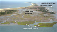
2007 oblique aerial photograph looking west across the east end of Shackleford Banks.
The 2007 oblique aerial photograph looks west across the east end of Shackleford Banks. Barden Inlet is at the bottom with Back Sound on the right and the Atlantic Ocean is on the left side of the photograph.
Permission must be secured from the individual copyright owners to reproduce any copyrighted materials contained within this website. Digital assets without any copyright restrictions are public domain.
Figure A29 from Riggs et al. (2015).
Public domain:Full Granting Rights
Image
Cape Lookout National Seashore, Code: CALO
Cape Lookout National Seashore, Carteret County, North Carolina
Latitude: 34.9581985473633, Longitude: -76.1900024414063
Latitude: 34.9581985473633, Longitude: -76.1900024414063
01/01/0001
Public Can View
Thursday, August 5, 2021 10:49:23 AM
Thursday, August 5, 2021 1:02:27 PM
51_CALO_Riggs_etal_2015_A29.jpg
Monday, January 1, 0001 12:00:00 AM
jpg
121.3 kB
Scenic