Select Item below to DOWNLOAD - Once item is selected, right click and choose 'save as'
0FBF7EEE-BED4-7384-B7B24A3291FC23BD
Site Plan
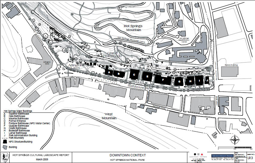
A map shows the location of the row of bathhouses in the downtown context.
Bathhouse Row. A site plan shows the cluster arrangement of bathhouses in the context of downtown Hot Springs. Although the eight existing bathhouses were built independently under separate owners and with individual intentions about their interior and exterior appearances, their collective effect defines the historic character of the landscape. The preservation of the Magnolia Promenade to the west and the construction of the Grand Promenade to the east reinforces the linear effect of Bathhouse Row.
U.S. National Park Service
Permission must be secured from the individual copyright owners to reproduce any copyrighted materials contained within this website. Digital assets without any copyright restrictions are public domain.
NPS, 2010
Public domain:Full Granting Rights
Image
Hot Springs National Park, Code: HOSP
34.51375, -93.05381
Hot Springs National Park, Garland County, Arkansas
Latitude: 34.511100769043, Longitude: -93.0896987915039
Hot Springs National Park, Garland County, Arkansas
Latitude: 34.511100769043, Longitude: -93.0896987915039
Public Can View
Wednesday, September 12, 2018 3:09:25 PM
Wednesday, September 12, 2018 3:09:25 PM
0FBF85F0-D62B-148F-E41424A450D4C26B.jpg
Monday, December 13, 2010 7:16:26 PM
jpg
175.8 kB
Scenic