Select Item below to DOWNLOAD - Once item is selected, right click and choose 'save as'
0d229de6-5750-4ed0-b7d2-1605da78301b
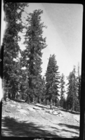
Mixed Conifer Forest, 1 1/2 mi ENE of Colony Meadow, Type Map.
SEKI Historic Image
Mixed Conifer Forest, 1 1/2 mi ENE of Colony Meadow, Type Map.
National Park Service
R.D. Roseberry, 361006, Colony Meadow area, SNP, Mixed Conifer Forest, 1 1/2 mi ENE of Colony Meadow, Type Map.
Permission must be secured from the individual copyright owners to reproduce any copyrighted materials contained within this website. Digital assets without any copyright restrictions are public domain.
Public domain
Image
Colony Meadow area, Tulare County, California
10/06/1936
option 1
Tuesday, January 10, 2017 1:00:25 PM
Tuesday, January 10, 2017 1:00:25 PM
08243.tif
Monday, January 1, 0001 12:00:00 AM
tif
15.3 MB
Scenic
,
Historic