Select Item below to DOWNLOAD - Once item is selected, right click and choose 'save as'
0b4c21b3-c596-41de-905f-6b390bf05d92
-16fd90a512522870.png
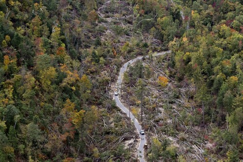
Aerial view of dozens of fallen trees and a road
Aerial Shot of the Heritage Trail in the Fall after the storm.
Permission must be secured from the individual copyright owners to reproduce any copyrighted materials contained within this website. Digital assets without any copyright restrictions are public domain.
Image credit: Cory Morse, MLive.com
Public domain:Full Granting Rights
Image
Sleeping Bear Dunes National Lakeshore, Code: SLBE
Sleeping Bear Dunes National Lakeshore, Michigan
Latitude: 45.1077919006348, Longitude: -86.0129470825195
Latitude: 45.1077919006348, Longitude: -86.0129470825195
Public Can View
Wednesday, January 19, 2022 1:48:14 PM
Wednesday, January 19, 2022 1:50:54 PM
-16fd90a512522870.png
png
296.4 kB
Scenic