Select Item below to DOWNLOAD - Once item is selected, right click and choose 'save as'
0aa7122d-2790-487d-9f03-896f95ba8b3f
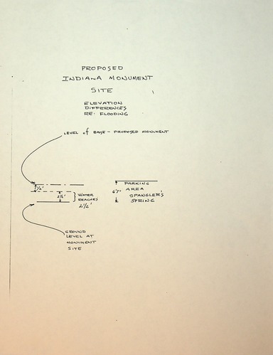
30. Sketch of Flooding Levels at Proposed Indiana Monument Site, N. D.
Typed Document
PROPOSED INDIANA MONUMENT SITE
ELEVATION DIFFERENCES
RE: FLOODING
[arrow pointing to top line below on left] LEVEL OF BASE - PROPOSED MONUMENT
— — — — — —
— - — - — - — PARKING AREA
[double headed vertical arrow] ½’ SPANGLER’S SPRING
— - — - — [double headed vertical arrow]
2 ½’ [double headed vertical arrow] } WATER REACHES 2 ½’ 6’7”
— - — - —
[arrow pointing to bottom line above on left] GROUND LEVEL AT MONUMENT SITE]
Permission must be secured from the individual copyright owners to reproduce any copyrighted materials contained within this website. Digital assets without any copyright restrictions are public domain.
NPS Photo
Public domain:Full Granting Rights
Image
Gettysburg National Military Park, Code: GETT
Gettysburg National Military Park, Adams County, Pennsylvania
Latitude: 39.804500579834, Longitude: -77.2384033203125
Latitude: 39.804500579834, Longitude: -77.2384033203125
01/01/0001
Public Can View
Monday, August 11, 2025 8:28:21 PM
Tuesday, August 12, 2025 3:16:18 PM
Document 30.jpg
Monday, January 1, 0001 12:00:00 AM
jpg
636.6 kB
Scenic