Select Item below to DOWNLOAD - Once item is selected, right click and choose 'save as'
0a732024-9c77-43ad-b191-eb98e6110096
Note
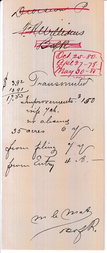
Scanned image of form. See description for text.
Division P
FR Williams
BafR
Oct. 25 – 80.
Apl 27 – 78.
May 30 – 85
Transmuted
$3.92
13.91
17.83
Improvements. $150
Wife 1 ch. [child]
No absence
35 acres 6yr
From filing 7yr
From entry 4. 8.—
M Le Mas [?]
Baf R.
Federal records are in the public domain
Public domain
Document
Homestead National Historical Park, Code: HOME
Graham County, Kansas
Latitude: 40.2879981994629, Longitude: -96.8339004516602
Latitude: 40.2879981994629, Longitude: -96.8339004516602
09/25/2018
01/01/1885 - 12/30/1887
Land Entry Case Files: Homestead Final Certificates. Record Group 49: Records of the Bureau of Land Management. National Archives and Records Administration.
Public Can View
Organization: Homestead National Historical Park
Address: 8523 W State Hwy 4, Beatrice, NE 68310
Address: 8523 W State Hwy 4, Beatrice, NE 68310
Wednesday, June 2, 2021 10:48:14 AM
Thursday, July 17, 2025 7:17:35 PM
RG49.B1165.F.8816.4.tif
CanoScan CanoScan, LiDE 220
Monday, September 24, 2018 6:59:14 PM
tif
6.7 MB
Historic